
Study results are presented by general groupings of temperature, dissolved oxygen, nutrients, conductance, and general minerals. Discussion of the interrelationships is included with the results and summarized in the conclusion section.
Temperature
Temperature is an important water quality parameter with respect to its relationship to biological communities. There is currently no numeric objective for temperature in the Shasta River. 13.3° C is generally recognized as the optimum temperature for maintenance of most life stages for salmonid populations. 19.7° C is considered to be the temperature at which chronic stress effects occur (DF&G 1993).
During the period of this study, from June of 1986 through July of 1992, 316 temperature measurements were recorded by staff of the Regional Water Quality Control Board. Of these measurements, temperatures were 13.4° or higher 81.66% of the time, exceeding 19.6° C 37.72% of the time (Figure 2)
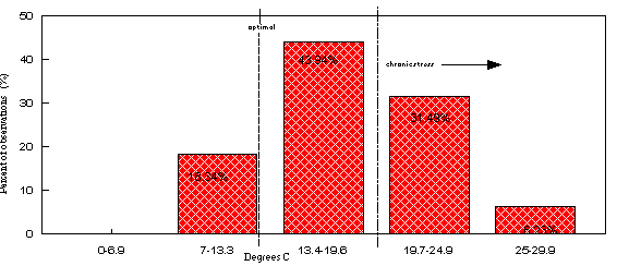
Figure 2. Temperature distribution of 289 measurements at selected stations on the Shasta River, April 1 through October 1, for the period of July, 1986 through June, 1991.
During the irrigation season, usually from April to the beginning
of October, median values for temperature ranged from 16.6°
C at ELR near the Dwinnell Reservoir to 20.9° C at HWY5 30
miles downstream. Maximum temperatures during the study period
varied from 21.0° C at AGER to 29.1° C at MGR. Water
temperatures generally increased from ELR (River Mile 31.85) to
HWY5 (RM 8.00), then decreased below HWY5 to 263 (Figure 3). The
median showed a drop of nearly 2° C between DWIN and ELR,
thereafter increasing steadily to a total rise of about 2°
C at HWY3. Between HWY3 and HWY5, there was an increase in median
temperatures of more than 3° C. Finally, the median values
dropped more than 3° C between HWY5 and 263 (Figure 3).
The Basin Plan (NCRWQCB, 1989) objective for DO2 in the Shasta
River is a minimum of 7.0 mg/L, with a median of 9.0 mg/L. DO2
levels of 5 mg/L or less are generally considered to be immediately
threatening to the survival of most fish species. Of a total of
296 DO2 measurements taken at all stations, 3.4% were less than
5 mg/L, 15.2% were less than 7 mg/L (Figure 4).
Table III. Percent of time D.O. was <7 mg/L & <5 mg/L at selected stations:
| Station | <7 mg/L | <5 mg/L |
| A-12 | 3.9% | 0 |
| HWY3 | 19.6% | 7.1% |
| HWY5 | 16.1% | 3.4% |
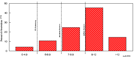
Figure 4. Dissolved oxygen: distribution of measurements at selected stations on the Shasta River, April 1 through October 1, for the period from July, 1986 through June 1992.
Median DO2 values ranged from 8.6 mg/L at DWIN to 10.4 mg/L at both ELR and 263. Dissolved oxygen medians gradually decreased downstream from ELR to HWY3, then decreased markedly between HWY3 and AGER by 2.3 mg/L, finally increasing over 3 mg/L between AGER and HWY5.
Of additional interest was the observation of wide swings in DO2
levels at a given station (Figure 5). Round the clock measurements
of DO2 levels indicated a high rate of photosynthetic productivity
during sunny periods, and a high rate of oxygen demand during
dark periods
(Figure 6).
Preliminary work done with light bottle/dark bottle analysis of aqueous samples showed no measurably significant effect on DO2 levels from suspended algae (algae in the water column). On the other hand, preliminary tests with samples of the filamentous algae found in abundance on the river bottom, particularly at stations where wide DO2 swings were measured, yielded extremely high levels of photosynthetic production (high DO2) with very low levels of respiration (Figure 7)

Figure 7. Dissolved oxygen productivity and demand in river and light bottle/dark bottle. Shasta River, September 16, 1992.
It is likely that sediment loads of nutrient rich detritus may contribute significantly to biological oxygen demand in certain sections of the river. This is further supported by the observations of lowest DO2 values at HWY3 and AGER Road, both low-velocity, deep-pool impoundments of the type which tend to collect organic debris and display very little mechanical aeration.
Nutrients - Biostimulatory Substances
Nitrogen and phosphorous compounds are primary plant nutrients. When either of these are the limiting nutrient, any increase will stimulate plant growth in aquatic systems, hence, they are referred to as biostimulatory substances. The Basin Plan contains a narrative objective for biostimulatory substances: "Waters shall not contain biostimulatory substances in concentrations that promote aquatic growths to the extent that such growths cause nuisance or adversely affect beneficial uses." Nuisance growth related problems exist with respect to at least one beneficial use: irrigation. Casual observation of the constant cleaning required at diversion pumps such as those at MGR to keep aquatic plant growth out of the pump intake is testimony to this.
Phosphorus is a primary plant nutrient which occurs naturally in some groundwater aquifers. Another main source of phosphorus is animal waste and fertilizer products associated with agricultural practices. Phosphorus was found to be present in sufficient concentrations for plant growth in nearly all samples from the river. The lowest phosphorus concentrations were in samples taken from the DWIN and CANAL stations just below Dwinnell Reservoir. There is a general trend of increasing phosphorus with movement downstream, with the largest increase downstream of HWY3. Concentrations at HWY5 station were slightly higher (Figure 8). Phosphorus concentrations ranged from non-detect (less than 0.010 mg/L) on four samples (once at stations MGR and DWIN, twice at CANAL) to 0.760 mg/L at ELR and 1.9 mg/L at AGER. Median concentrations ranged from 0.085 at DWIN, 0.115 mg/L at CANAL, and 0.27 at HWY5.
In water, ammonia is measured as total ammonia-nitrogen (NH3-N) and exists in equilibrium with the hydrolyzed form, ammonium hydroxide. U.S. EPA criteria for ammonia are based on the occurrence of un-ionized ammonia as a function of total ammonia, temperature, and pH (Appendix 2). For a given concentration of total ammonia in water, as either temperature or pH increases, the concentration of un-ionized ammonia also increases. Un-ionized ammonia is the fraction of total ammonia which is toxic to aquatic organisms. Total ammonia-nitrogen (NH3-N) is formed by chemical and bacterial decomposition or breakdown of plant and animal matter, principally protein-bearing materials. Ammonia is relatively quickly oxidized to other forms of nitrogen: nitrite then nitrate. High levels of NH3-N in surface waters normally indicate a relatively recent source, either from discharge of NH3, or from high decomposition rates in the absence of oxygen. Additionally, high levels of NH3-N in surface water can lower dissolved oxygen levels during the oxidation process. Ammonia concentrations were generally low, most frequently below analytical detection limits (Figure 9).
In surface water, ammonia oxidizes, first to nitrite (NO2), then quickly to nitrate (NO3). NO3 is readily used by algae and vascular plants as a primary nutrient, and is often the limiting nutrient in stream and river systems. High concentrations of NO3 can promote growth of algae and aquatic plants. Large amounts of aquatic plant growth can cause wide swings in dissolved oxygen levels by increasing dissolved oxygen through photosynthetic activity during daylight hours, while conversely decreasing dissolved oxygen levels at night through respiration. Decomposition of dead and dying plant matter exacerbates the decreasing oxygen, with adverse impacts on aquatic life. The median concentrations of NO3 observed during the study period ranged from non-detect (less than 0.05 mg/L) at HWY5, AGER, HWY3, MGR and CANAL, to 0.100 mg/L at 263 (Figure 10).
Total Kjeldahl Nitrogen (TKN) is the sum of organic nitrogen (from plant and animal matter) plus ammonia. In the Shasta River, the major component of TKN was organic nitrogen. TKN values varied, with the median upstream concentration at DWIN being the same value as the median downstream-most concentration at 263 (Figure 11). However, there are significant freshwater springs which enter the river below Dwinnell Reservoir. Springs of the type found in this area do not commonly have measurable levels of TKN or nitrate. Consequently, TKN values decrease from a median of 0.48 mg/L at DWIN to a median of 0.28 at A-12, where significant spring flows are noted. After this, TKN values increased to a median of 0.37 mg/L at MGR, 0.46 mg/L at HWY3, and 0.64 mg/L at AGER, thereafter decreasing to a median of 0.56 mg/L at HWY5 and 0.48 mg/L at 263. Significant mass loading of TKN occurs below A-12, possibly from the Little Shasta River or other return flows.
Specific conductance (SC) is a measure of the electrical conductance by water at 25° C, and is a function of the concentration of dissolved solids in solution. The higher the concentration of dissolved solids in solution, the higher the SC of the water. The Basin Plan objective for specific conductance in the Shasta River is a maximum not exceeding 800 micro-mhos, and a median not exceeding 600 micro-mhos.
There was one measurement where the Basin Plan objective for a maximum conductance was not met. Also, the Basin Plan objective of a maximum median value of 600 micro-mhos specific conductance was exceeded slightly more than 50% of the time at stations MGR and HWY3, and was exceeded at HWY5 always during the irrigation season. It is believed that the major sources of dissolved solids in the Shasta River are mineralized spring water and surface runoff of irrigation water. During the irrigation season CANAL water below Dwinnell had a range of 270 micro-mhos to 357 micro-mhos, while SC values at HWY5 ranged from 508 micro-mhos to 771 micro-mhos. The SC at CANAL was relatively constant, while SC in the river varied considerably in response to inputs, and dilution from lower conductivity sources. Specific conductance displayed a general increase from upstream to downstream, with some dilution from unknown sources occurring below AGER Road (Figure 12). Big Spring Creek at the bridge(BSB) was observed to have a much lower SC than the river at ELR. On one date, SC was 275 micro-mhos at CANAL, 394 micro-mhos at DWIN, 590 micro-mhos at ELR, and 341 micro-mhos at BSB. On a second date, SC was 279 micro-mhos at CANAL, 288 micro-mhos at DWIN, 573 micro-mhos at ELR, and 352 micro-mhos at BSB. SC is most probably increased from return flows in the area of Hole in the Ground, Hidden Valley, and Parks Creek, as well as possibly some springs with high SC. Inversely, SC is decreased by flows from Big Spring Creek and other freshwater flows downstream of ELR.
Alkalinity of water refers to an ability to accept hydrogen ions, to neutralize acid, and is a direct counterpart to acidity. High alkalinity has the effect of buffering or resisting pH change, and consequently reducing effects on pH from biological sources. Buffering is a function of the presence in water of a weak, or slightly ionized, acid (mainly calcium and magnesium carbonates, and HCO3- formed from CO2 and water), together with the salt of a weak acid, typically bicarbonates, carbonates, chlorides, nitrates, and sulfates of calcium, magnesium, and iron normally found in streams of this type. CO2 enters the water through decomposition, plant and algal respiration, and from the atmosphere. Alkalinity was moderate to high, ranging from 128 mg/L to 474 mg/L, with a median value of 239 mg/L (Figure 13).
Alkalinity was lowest immediately below Dwinnell Reservoir at DWIN and CANAL, where it never exceeded 182 mg/L. Levels increased sharply at ELR, thereafter showing a general trend of increasing alkalinities downstream (though some dilutional effects were measured in slightly lower alkalinity levels at A-12) (Figure 13).
The river also had a high pH, ranging from pH 7.2 to pH 9.6, with a median value of pH 8.2 (Figure 14)
Basin Plan objectives for pH in the Shasta River are 6.5 to 8.5. All stations exceeded the maximum objective of pH 8.5 occasionally. The general trend in pH was decreasing from the canal below Dwinnell Reservoir and in the river at DWIN, where the Basin Plan maximum pH of 8.5 was exceeded more than 50% of the time, then increasing again from HWY3 downstream. The Basin Plan maximum pH was exceeded in 50% of the measurements at station 263.
There was a trend of daily fluctuations in pH, with the lowest values being attained in the early morning (Figure 15). As the day progressed toward noon, pH values increased, until several hours later when there was an observable drop in pH values. Those relationships are caused by increased photosynthesis during the day, removing CO2 from the water and allowing the pH to rise. The reverse occurs at night, with plant respiration and decomposition releasing CO2 to the water and driving pH downward.
Arsenic was not found in detectable concentrations in DWIN or CANAL. Arsenic was found to occur at ELR in all but one sample, in every sample from downstream of ELR, and in one sample from Big Spring Creek. Concentrations ranged from 0.007 mg/L at 263 to 0.020 mg/L at ELR. Arsenic was higher than 90% of measures in 196 other streams (CVRWQCB, 1990). The Water Quality Control Plan for Inland Surface Waters of California (ISWP)(SWRCB 1991) objective for arsenic is not to exceed 0.190 mg/L for a 4-day average, and not to exceed 0.360 mg/L over a 1-hour average. Sodium and chloride levels were seen to increase going downstream. Sulfate levels were highly variable (Figure 16). (This will be related to p.18 discussion regarding CO3->SO4 shift in a future report.)
Note on Yreka Creek: During sampling on the Shasta River, Yreka Creek was often sampled as a major tributary. Substantial loading of ammonia, boron, chloride, iron, phosphorus, and potassium were found to occur downstream of the Yreka Publicly Owned Treatment Works (POTW), when compared to samples from adjacent to and upstream of the POTW. Staff of the Regional Board's Northern District are working with the Yreka POTW on this issue.


