Selected Examples of Mass Wasting
|
by Bob Musgrove Geography 581 Geomorphology Professor: Dr. Mairs Southern Oregon University |
SNOW AVALANCHES
Avalanches as a Mountain Hazard
|
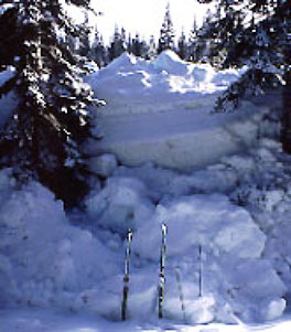 Figure 1. The above shows the snow depth in the runout zone of a large avalanche that occured on Mt. Shasta on January 1, 1997. Photograph by Eric White. That's a pair of skis in the foreground. |
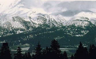
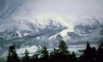
Photos by Jane English. |
Avalanches on Mount Shasta
In January, 1995, the snow depth on Shasta was at a 20-year high, and conditions were optimal for record-setting avalanches. The Mount Shasta Herald interviewed U.S. Forest Service officials for information as to the extent of the destruction and for details on avalanche conditions. Forest Service scientist Peter Van Susteren reported that one of the largest avalanches crossed the Everitt Memorial Highway, plucking boulders from the soil, destroying 300-year-old growth forest, and leaving a path of devastation 150 feet wide and up to 25 feet deep. During the same time period another very large avalanche scoured the slopes of Shastina, leaving six distinct paths through old growth forest. |
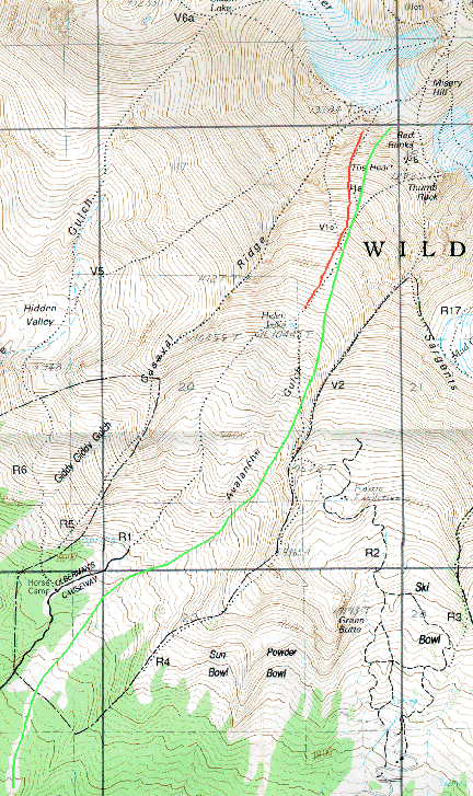
The rain-related events of of January 1, 1997 are memorable to anyone who was living in southern Oregon or northern California at that time. A particularly enormous wet snow avalanche occurred in Avalanche Gulch on January 1 during a rain-on-snow event at high altitude (Towner 1999). According to my own field observations at the time and subsequent figuring with a topographic map, the avalanche's starting zone was at an altitude of approximately 12,700 feet and it finally came to a stop at 7,400 feet , a little over a vertical mile below. The avalanche's track was over four miles long, making for a "vertical drop" to "horizontal run" ratio of .25 to 1. This avalanche deposited snow to an estimated depth of 20 feet at the lower elevations and the terminal mounds of snow persisted into the following winter. Large avalanches such as those described above represent an ongoing threat to backcountry visitors. The 1995 slide buried the site of a then-proposed ski lodge, as reported in the Mount Shasta Herald story referred to above. Figure 4. The green line on the map show the path of the January 1997 slide in Avalanche Gulch. The red line refers to the debris flow discussed elswhere on the website. (USGSmap) |
 |
Causes of Avalanches on Mount Shasta
Avalanche forecasters divide avalanches into 3 main parts: the starting zone with slopes of 30 to 50 degrees, the track with slopes of 20 to 30 degrees, and the runout zone with slopes less than 20 degrees (Armstrong and Williams 1986). An avalanche might start when a more dense snowfall is deposited on top of a less dense layer of snow, resulting the formation of a slab that is not well bonded to the weaker snow below (Armstrong and Williams 1986). On the slopes of Mount Shasta, shear strength holds snow in place, and shear failure can occur if the stress is strong enough to overwhelm the forces of cohesion and resistance in the layers of snow (Easterbrook 1999). On Mount Shasta factors that may increase stress leading to shear failure include the deposition of rain on snow and the warming and partial melting of the upper layers of snow. |
web page authored by Bob Musgrove