|
A Mount Shasta Jokulhlaup
While California's mountains are home
to many remnant glaciers, few fossil records exist to document
past occurrences of jokulhlaups (Hill and Engenhoff 1976). The
most notable exception to the above are the events associated
with the mass wasting that originated on the Konwakiton Glacier
on Mount Shasta between 1881 and 1931 (Hill and Engenhoff 1976).
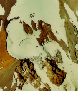
The Konwakiton is a relatively small glacier, even for Mount
Shasta, and is currently less than 0.7 kilometer long and less
than 0.4 kilometer wide. It is located adjacent to the standard
Avalanche Gulch climbing route and seemed relatively stable when
viewed by myself from Thumb Rock in 1998. Late in the summer
climbing season a large bergshrund and several crevasses open
up and present potential hazards to climbers who venture off
route. Despite its current benign appearance, the Konwakiton
has, in the geologically recent past, presented a hazard to area
residents and to nearby rivers.
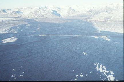
Figure
6. The Konwakiton Glacier. USFS aerial
photograph.
The Konwakiton Glacier drains into Mud Creek
canyon, which discharges into the McCloud River, which joins
the Pitt River before feeding into the Sacramento River and eventually,
San Francisco Bay. In August 1924 a camper in Mud Creek canyon
was alarmed by a loud roaring sound accompanied by a trembling
of the ground. He soon saw, and quickly escaped from a liquid
torrent of earth and debris which enveloped his campsite. The
water supply for the town of McCloud was disrupted by the flow
and lumber company employees sent to repair the damage reported
difficultly with pieces of ice as large as houses. The flow soon
blocked the road to Sisson (present day Mt. Shasta City) and
was up to a half mile wide and twenty feet deep (Hill and Egenhoff
1976).
That the mud flow was the result of a glacial
outburst, a jokulhlaup, was suspected, and on August 21 locals
climbed up to the Konwakiton to investigate. "McCloud people
are confident that what is left of the glacier near the top is
frozen tight it its moorings," the local newspaper reported
(Hill and Egenhoff 1976, p. 155). The site became a popular hiking
destination, and people expressed confidence that, unless the
weather warmed up, the danger was past. However temperatures
did rise, the jokulhlaup resumed its destructive flow, and soon
it was 5 miles long, up to 1 mile wide, and 10 feet deep. The
alluvial fan created by the flow was reported to encompass 1,500
acres and to hold a volume of 7 million cubic yards of debris.
Plants were unable to reestablish themselves in the wake of the
devastation. The jokulhlaup polluted the rivers downstream and
carried ash into the Sacramento River. The event continued, and
up high on Mount Shasta, the torrent peaked at 2 or 3 o'clock
each afternoon, and local observers felt that melting of glacial
ice by the afternoon sun was the cause of increased flow (Hill
and Engenhoff 1976).
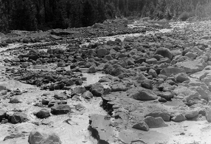
Figure
7. This 1997 mudlfow on Mount Shasta
produced devastation similar to the events of 1924.
In 1925 the California Debris Commission conducted
an investigation into the causes and mechanisms of the jokulhlaup.
Engineer R. L. Egenhoff reported that the "main part of
the glacier was about 800 feet wide and 100 feet thick....the
material underneath the end of the glacier consisted of unconsolidated
volcanic debris of all kinds." He went on to describe the
scene: "two large caverns, each about 300 feet wide....extending
two or three hundred feet back under the glacier.... a waterfall
from under the ice was pouring out of each cavern over the caving
material." (Hill and Engenhoff 1976, p. 157).
Causes of the Jokulhlaup on Mount Shasta
On slopes shear strength holds materials, including
glacial ice and volcanic debris, in place. Shear failure can
occur if the stress is strong enough to overwhelm the forces
of cohesion and resistance in the layers of material (Easterbrook
1999). It may be the case that the melting of the Konwakiton
due to increased temperature led to the saturation of the debris
which supported that glacier, which in turn led to an increase
in stress as the debris reached its plastic or liquid limit (Van
Susteren). Thus the increase in atmospheric temperature may have
led to a sequence of events resulting in the failure of the materials
which supported the glacier.
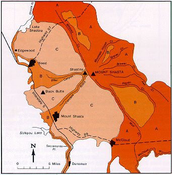
Figure 8. USFS
mud flow hazard map. The dark orange areas are of the greatest
hazard, followed by the lighter orange areas of intermediate
hazard, and the pink areas are of minimum hazard. (Crandell and
Nicols, 1987)
|